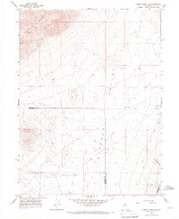
1965 Map of Cherry Creek NE
USGS Topo · Published 1967About this map
Buffalo Mountain dominates the northwestern corner of this mid-1960s survey, its slopes descending into the broad expanse of Buffalo Valley. This high-desert landscape in northern Nevada is characterized by a network of intermittent drainage and light industrial activity typical of the Great Basin's mining history. Evidence of mineral exploration and resource extraction is visible through several prospects and multiple gravel pits scattered across the basin floor. The map records the point where Humboldt, Pershing, and Lander counties meet, marking a remote tri-county boundary. Water is a critical and sparse resource here, represented by a single Well and the seasonal flows of Trenton Creek and Mill Cr in the southeast. A rugged Jeep Trail provides the primary means of traversal through the valley, connecting the scattered industrial sites across the arid terrain.
Find a feature on this map
12 named features on this map. Tap any name to fly to it.
Don’t see what you’re looking for? This feature index may not catch every label — zoom into the map to look around manually.
Map Details
Editions of this 1965 Cherry Creek NE Map
2 editions found
Other maps of this area

1932 · Sonoma Range
USGS Topo · 1:250,000

1939 · Sonoma Range
USGS Topo · 1:250,000

1940 · Antler Peak
USGS Topo · 1:62,500

1943 · Antler Peak
USGS Topo · 1:62,500

1955 · Winnemucca
USGS Topo · 1:250,000

1958 · Winnemucca
USGS Topo · 1:250,000

1962 · Winnemucca
USGS Topo · 1:250,000

1965 · Goldrun Creek
USGS Topo · 1:24,000

1965 · Edna Mountain
USGS Topo · 1:62,500
1965 · Brooks Spring
USGS Topo · 1:24,000