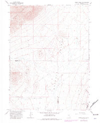
1965 Map of Cherry Creek NE
USGS Topo · Published 1981About this map
Buffalo Mountain and the surrounding high desert terrain dominate this Nevada survey, which captures the industrial and natural landscape during the mid-1960s with updates into the early 1980s. The map highlights the intersection of three counties—Humboldt, Pershing, and Lander—marked by boundary lines that traverse the arid basin of Buffalo Valley. Sparse but significant human activity is evident through resource extraction sites, including scattered Prospects and several Gravel Pits.
Find a feature on this map
11 named features on this map. Tap any name to fly to it.
Don’t see what you’re looking for? This feature index may not catch every label — zoom into the map to look around manually.
Map Details
Editions of this 1965 Cherry Creek NE Map
2 editions found
Other maps of this area

1932 · Sonoma Range
USGS Topo · 1:250,000

1939 · Sonoma Range
USGS Topo · 1:250,000

1940 · Antler Peak
USGS Topo · 1:62,500

1943 · Antler Peak
USGS Topo · 1:62,500

1955 · Winnemucca
USGS Topo · 1:250,000

1958 · Winnemucca
USGS Topo · 1:250,000

1962 · Winnemucca
USGS Topo · 1:250,000

1965 · Goldrun Creek
USGS Topo · 1:24,000

1965 · Edna Mountain
USGS Topo · 1:62,500
1965 · Brooks Spring
USGS Topo · 1:24,000