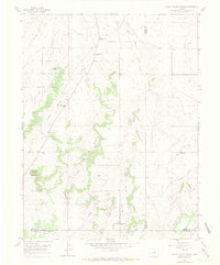
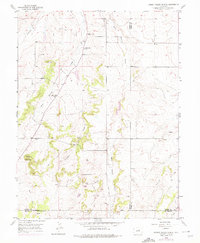
1954 Map of Cherry Valley School
USGS Topo · Published 1971About this map
Cherry Valley School stands as a central landmark in this mid-century mapping of rural Colorado, where the high plains meet the transition to the foothills. The landscape is defined by the convergence of several major drainages, including West Cherry Creek and East Cherry Creek, which carve through the terrain south of Franktown. This 1954 survey, updated with 1969 aerial revisions, documents a shifting educational landscape in Douglas and Elbert counties. While the primary school remains active, the presence of the Cherry Sch (Aban'd) and Pine Grove Sch (Aban'd) suggests the consolidation of earlier pioneer-era school districts. The topography rises toward Bucks Mountain in the west, while a network of Jeep Trail routes and seasonal waterways like Iron Springs Gulch trace the remote canyons of the divide.
Find a feature on this map
15 named features on this map. Tap any name to fly to it.
Don’t see what you’re looking for? This feature index may not catch every label — zoom into the map to look around manually.
Map Details
Editions of this 1954 Cherry Valley School Map
6 editions found
Other maps of this area

1894 · Castle Rock
USGS Topo · 1:125,000

1913 · Castle Rock
USGS Topo · 1:125,000

1939 · Elizabeth
USGS Topo · 1:62,500

1940 · Elbert
USGS Topo · 1:62,500

1940 · Castle Rock
USGS Topo · 1:62,500

1944 · Elbert
USGS Topo · 1:62,500

1945 · Castle Rock
USGS Topo · 1:62,500

1945 · Elizabeth
USGS Topo · 1:62,500

1953 · Denver
USGS Topo · 1:250,000

1954 · Cherry Valley School
USGS Topo · 1:24,000