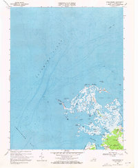
1968 Map of Chesconessex
USGS Topo · Published 1971About this map
Pocomoke Sound and the Chesapeake Bay meet at this intricate section of the Virginia shoreline in the late 1960s. The landscape is dominated by a complex network of wetlands and islands, including the expansive Big Marsh and the aptly named Tobacco Island. Narrow waterways such as The Thorofare and Bad Gut carve through the tidal flats, illustrating the difficult maritime navigation of the era. On firmer ground, the small settlement of Chesconessex serves as a local hub near the mouth of Chesconessex Creek.
Find a feature on this map
34 named features on this map. Tap any name to fly to it.
Don’t see what you’re looking for? This feature index may not catch every label — zoom into the map to look around manually.
Map Details
Editions of this 1968 Chesconessex Map
3 editions found
Other maps of this area

1903 · Crisfield
USGS Topo · 1:62,500

1920 · Crisfield
USGS Topo · 1:62,500

1931 · Accomac
USGS Topo · 1:48,000

1935 · Accomac
USGS Topo · 1:62,500

1942 · Chesconessex
USGS Topo · 1:31,680

1942 · Nandua Creek
USGS Topo · 1:24,000

1942 · Great Fox Island
USGS Topo · 1:24,000

1942 · Tangier Island
USGS Topo · 1:24,000

1942 · Saxis
USGS Topo · 1:24,000

1942 · Parksley
USGS Topo · 1:24,000