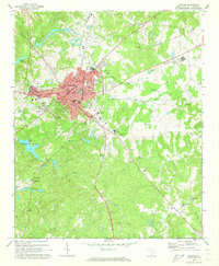
1969 Map of Chester
USGS Topo · Published 1973About this map
The rail hub of Chester serves as the focal point of this 1969 survey, where four distinct rail lines—the Southern, Seaboard Coast Line, Lancaster and Chester, and Carolina and Northwestern—converge to define the town’s industrial character. The map documents the community’s mid-century civic infrastructure, including the County Hospital, City Hall, and the Center for Retarded Children. Beyond the urban center, the landscape transitions into the wooded recreation areas of Chester State Park and the Campground near Cedar Rock Ch. Genealogists will find significant value in the numerous rural congregations and burial grounds, such as Old Purity Cem, Evergreen Cemetery, and Sandy River Ch, which anchor the surrounding countryside alongside smaller settlements like Evans and Orrs.
Find a feature on this map
63 named features on this map. Tap any name to fly to it.
Don’t see what you’re looking for? This feature index may not catch every label — zoom into the map to look around manually.
Map Details
Editions of this 1969 Chester Map
2 editions found
Other maps of this area

1907 · Sharon
USGS Topo · 1:62,500

1941 · Spartanburg
USGS Topo · 1:250,000

1949 · Rock Hill
USGS Topo · 1:62,500

1953 · Spartanburg
USGS Topo · 1:250,000

1960 · Spartanburg
USGS Topo · 1:250,000

1963 · Spartanburg
USGS Topo · 1:250,000

1964 · Spartanburg
USGS Topo · 1:250,000

1968 · Blackstock
USGS Topo · 1:24,000
1969 · Stover
USGS Topo · 1:24,000
1969 · Richburg
USGS Topo · 1:24,000