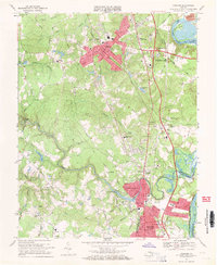
1969 Map of Chester
USGS Topo · Published 1971About this map
Chester and the northern edge of Colonial Heights dominate this late-1960s landscape, illustrating a period of significant suburban expansion between Richmond and Petersburg. The Seaboard Coast Line railroad runs as a central spine through the region, supporting local industry and transit near established settlements like Ashton and Walthall. Residential development is concentrated in neighborhoods such as Sherwood Hills and Lakeview, while the presence of John Tyler College and numerous institutions like St Johns Ch and Curtis Sch reflect a growing community infrastructure.
Find a feature on this map
83 named features on this map. Tap any name to fly to it.
Don’t see what you’re looking for? This feature index may not catch every label — zoom into the map to look around manually.
Map Details
Editions of this 1969 Chester Map
4 editions found
Other maps of this area

1894 · Bermuda Hundred
USGS Topo · 1:62,500

1894 · Petersburg
USGS Topo · 1:62,500

1897 · Amelia
USGS Topo · 1:125,000

1938 · Dutch Gap
USGS Topo · 1:24,000

1938 · Drewrys Bluff
USGS Topo · 1:24,000

1943 · Dutch Gap
USGS Topo · 1:31,680

1943 · Chesterfield
USGS Topo · 1:31,680

1943 · Hopewell
USGS Topo · 1:31,680

1943 · Beach
USGS Topo · 1:24,000

1943 · Sutherland
USGS Topo · 1:24,000