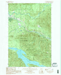
1989 Map of Chester Morse Lake
USGS Topo · Published 1989About this map
Chester Morse Lake serves as a critical hydrological hub for the region, managed within a protected watershed boundary that separates municipal water resources from the public recreation lands of Olallie State Park. This landscape is defined by the dramatic descent of the Middle Fork Snoqualmie River and South Fork Snoqualmie River, which frame Sallal Prairie and the community of Tanner. The map details a transition from industrial and utility infrastructure—including numerous Gravel Pits, a prominent Transmission Line, and a Powerplant—to the steep, forested slopes of Grouse Ridge and Mount Washington. Local history is visible in the presence of Camp Waskowitz and the Horseshoe Mine, while the RR Grade tracing the river valley highlights the corridor's long-standing role as a primary transportation route through the Cascades.
Find a feature on this map
49 named features on this map. Tap any name to fly to it.
Don’t see what you’re looking for? This feature index may not catch every label — zoom into the map to look around manually.
Map Details
Editions of this 1989 Chester Morse Lake Map
This is the sole edition of this map. No revisions or reprints were ever made.
Other maps of this area

1913 · Cedar Lake
USGS Topo · 1:125,000

1921 · Sultan
USGS Topo · 1:125,000

1923 · Sultan
USGS Topo · 1:125,000

1953 · Snoqualmie
USGS Topo · 1:24,000

1953 · North Bend
USGS Topo · 1:24,000

1953 · Eagle Gorge
USGS Topo · 1:24,000

1957 · Wenatchee
USGS Topo · 1:250,000

1960 · Mount Si
USGS Topo · 1:62,500

1960 · Bandera
USGS Topo · 1:62,500

1975 · Snoqualmie Pass
USGS Topo · 1:100,000