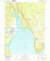
1979 Map of Chester
USGS Topo · Published 1979About this map
The Chester townsite sits at the intersection of the Feather River North Fork and the expansive northern reaches of Lake Almanor. This 1970s landscape is defined by the managed waters of the reservoir, where dashed blue patterns indicate areas of controlled inundation along the shorelines of Gould Swamp and Big Cove. The map detail reveals a community focused on timber and tourism, with the Almanor Ranger Sta and High Sch serving the local population while the Chester Airport and multiple campgrounds provide infrastructure for the surrounding Lassen National Forest.
Find a feature on this map
40 named features on this map. Tap any name to fly to it.
Don’t see what you’re looking for? This feature index may not catch every label — zoom into the map to look around manually.
Map Details
Editions of this 1979 Chester Map
4 editions found
Other maps of this area

1886 · Lassen Peak
USGS Topo · 1:250,000

1892 · Lassen Peak
USGS Topo · 1:250,000

1894 · Lassen Peak
USGS Topo · 1:250,000

1955 · Almanor
USGS Topo · 1:62,500

1955 · Westwood
USGS Topo · 1:250,000

1956 · Mt. Harkness
USGS Topo · 1:62,500

1956 · Chester
USGS Topo · 1:62,500

1958 · Westwood
USGS Topo · 1:250,000

1958 · Jonesville
USGS Topo · 1:62,500

1959 · Westwood
USGS Topo · 1:250,000