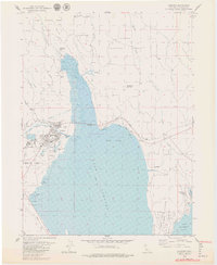
1979 Map of Chester
USGS Topo · Published 1979About this map
Chester sits at the northern reaches of Lake Almanor, serving as a central hub for this portion of the Lassen National Forest in the late 1970s. The town's grid is well-established between the North Fork Feather River and the Chester Airport, with development extending toward the Almanor Peninsula. The map captures the specialized land use of the era, from the industrial presence of several Gravel Pits to recreational infrastructure like Catfish Beach and the Last Chance Campground. To the north, the terrain transitions into the high country marked by Manzanita Mountain and Mud Butte. The intricate drainage systems of Mud Creek and Last Chance Creek feed into the reservoir, defining the watershed that sustained the local timber and hydroelectric economy of Plumas County during this period.
Find a feature on this map
33 named features on this map. Tap any name to fly to it.
Don’t see what you’re looking for? This feature index may not catch every label — zoom into the map to look around manually.
Map Details
Editions of this 1979 Chester Map
4 editions found
Other maps of this area

1886 · Lassen Peak
USGS Topo · 1:250,000

1892 · Lassen Peak
USGS Topo · 1:250,000

1894 · Lassen Peak
USGS Topo · 1:250,000

1955 · Almanor
USGS Topo · 1:62,500

1955 · Westwood
USGS Topo · 1:250,000

1956 · Mt. Harkness
USGS Topo · 1:62,500

1956 · Chester
USGS Topo · 1:62,500

1958 · Westwood
USGS Topo · 1:250,000

1958 · Jonesville
USGS Topo · 1:62,500

1959 · Westwood
USGS Topo · 1:250,000