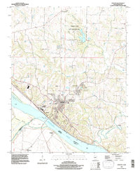
1968 Map of Chester
USGS Topo · Published 1993About this map
Chester sits prominently on the bluffs overlooking the Mississippi River, serving as a critical point of industry and administration along the Illinois-Missouri border. The landscape is defined by the massive footprint of the Menard State Correctional Center and the adjacent community of Menard, which occupy the riverfront north of the city center. Across the water, the low-lying Kaskaskia Island is protected by an extensive Levee system, reflecting the ongoing struggle to manage the river’s floodplain.
Find a feature on this map
34 named features on this map. Tap any name to fly to it.
Don’t see what you’re looking for? This feature index may not catch every label — zoom into the map to look around manually.
Map Details
Editions of this 1968 Chester Map
This is the sole edition of this map. No revisions or reprints were ever made.
Other maps of this area

1912 · Baldwin
USGS Topo · 1:62,500

1914 · Baldwin
USGS Topo · 1:62,500

1914 · Coulterville
USGS Topo · 1:62,500

1915 · Chester
USGS Topo · 1:62,500

1916 · Campbell Hill
USGS Topo · 1:62,500

1917 · Coulterville
USGS Topo · 1:62,500

1918 · Campbell Hill
USGS Topo · 1:62,500

1942 · Baldwin
USGS Topo · 1:62,500

1947 · Chester
USGS Topo · 1:62,500

1949 · Paducah
USGS Topo · 1:250,000