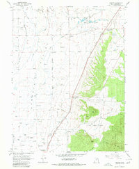
1966 Map of Chester
USGS Topo · Published 1980About this map
The Sanpete Valley floor in the mid-1960s is defined by a sophisticated network of irrigation and transport, dominated by the Denver and Rio Grande Western railroad corridor. Agricultural life centers on the settlement of Chester, where the Chester PO and nearby Rock Dam Canal illustrate the vital connection between rail access and water management. To the south, Pigeon Hollow Junction serves as a critical local waypoint at the base of the rising foothills.
Find a feature on this map
38 named features on this map. Tap any name to fly to it.
Don’t see what you’re looking for? This feature index may not catch every label — zoom into the map to look around manually.
Map Details
Editions of this 1966 Chester Map
2 editions found
Other maps of this area

1885 · Manti
USGS Topo · 1:250,000

1895 · Manti
USGS Topo · 1:250,000

1951 · Moroni
USGS Topo · 1:62,500

1956 · Price
USGS Topo · 1:250,000

1960 · Price
USGS Topo · 1:250,000

1962 · Price
USGS Topo · 1:250,000

1965 · Manti
USGS Topo · 1:24,000

1965 · Wales
USGS Topo · 1:24,000

1966 · Spring City
USGS Topo · 1:24,000

1966 · Chester
USGS Topo · 1:24,000