
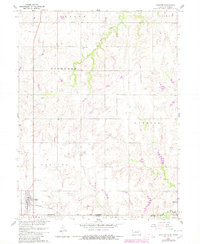
1960 Map of Chester
USGS Topo · Published 1961About this map
The borderlands of Thayer County, Nebraska, and Republic County, Kansas, are defined here by a landscape of grain farming and local drainage into Rose Creek and Dry Creek. Centered on the town of Chester, the map shows a 1960s agricultural environment anchored by the Chicago Burlington and Quincy railroad, which runs through the heart of the settlement. The survey illustrates the rural infrastructure of the mid-20th century, including several one-room schoolhouses like Belvidere View Sch and School No 77, which were already becoming relics of a disappearing educational system. Genealogists will find significant value in the documentation of several local burial grounds, including the Chester Cem, St Johns Cem, and Hubbell Cem, located near the village of Hubbell along the southern edge of the quadrangle.
Find a feature on this map
22 named features on this map. Tap any name to fly to it.
Don’t see what you’re looking for? This feature index may not catch every label — zoom into the map to look around manually.
Map Details
Editions of this 1960 Chester Map
2 editions found
Other maps of this area

1892 · Concordia
USGS Topo · 1:125,000

1893 · Washington
USGS Topo · 1:125,000

1898 · Hebron
USGS Topo · 1:125,000

1955 · Manhattan
USGS Topo · 1:250,000

1955 · Lincoln
USGS Topo · 1:250,000

1956 · Manhattan
USGS Topo · 1:250,000

1957 · Manhattan
USGS Topo · 1:250,000

1957 · Lincoln
USGS Topo · 1:250,000

1958 · Lincoln
USGS Topo · 1:250,000

1960 · Hubbell
USGS Topo · 1:24,000