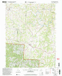
2002 Map of Chesterhill
USGS Topo · Published 2006About this map
Chesterhill stands as a focal point in this southeastern Ohio landscape where the borders of Morgan, Athens, and Washington Counties converge. The region is defined by the deep dissection of the Allegheny Plateau, with the West Branch Wolf Creek and its many tributaries, such as Coal Run and Shrader Run, carving narrow valleys through the hills. A significant portion of the southern terrain is dedicated to the Wayne National Forest, illustrating a land-use pattern centered on conservation and timber. Local history is deeply embedded in the rural landscape, visible through the high density of country churches and burial grounds like Friends Cem and Quaker Cem near Bartlett. These labels, along with the presence of a Covered Bridge on the eastern edge of the map, reflect the enduring Quaker heritage and traditional settlement patterns of the 19th-century pioneers who cleared these timbered ridges.
Find a feature on this map
41 named features on this map. Tap any name to fly to it.
Don’t see what you’re looking for? This feature index may not catch every label — zoom into the map to look around manually.
Map Details
Editions of this 2002 Chesterhill Map
This is the sole edition of this map. No revisions or reprints were ever made.
Other maps of this area

1902 · Parkersburg
USGS Topo · 1:62,500

1904 · Parkersburg
USGS Topo · 1:62,500

1904 · Chesterhill
USGS Topo · 1:62,500

1906 · Chesterhill
USGS Topo · 1:62,500

1909 · Caldwell
USGS Topo · 1:62,500

1910 · Mc Connelsville
USGS Topo · 1:62,500

1912 · Caldwell
USGS Topo · 1:62,500

1949 · Clarksburg
USGS Topo · 1:250,000

1956 · Clarksburg
USGS Topo · 1:250,000

1960 · Watertown
USGS Topo · 1:24,000