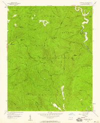
1956 Map of Chestnut Mtn.
USGS Topo · Published 1958About this map
Pisgah National Forest dominates this mid-century landscape, where the rugged intersections of Burke, Avery, and Caldwell counties meet along the eastern continental divide. The terrain is defined by steep ridges like Jonas Ridge and Ripshin Ridge, with deep drainages such as Wilson Creek and Upper Creek carving through the granite. Small pockets of settlement and family history are preserved at Mortimer and Kawana, the latter home to the Kawana Cem. This survey illustrates the remote character of the Blue Ridge before extensive modern development, highlighting historical landmarks such as the Lookout Tower on Chestnut Mtn and the isolated Parks Cem near the southern boundary. The network of creeks, including Estes Mill Creek and Raider Camp Creek, suggests the long-standing importance of water power and timber in these narrow mountain coves.
Find a feature on this map
58 named features on this map. Tap any name to fly to it.
Don’t see what you’re looking for? This feature index may not catch every label — zoom into the map to look around manually.
Map Details
Editions of this 1956 Chestnut Mtn. Map
4 editions found
Other maps of this area

1893 · Cranberry
USGS Topo · 1:125,000

1895 · Cranberry
USGS Topo · 1:125,000

1899 · Cranberry
USGS Topo · 1:125,000

1902 · Cranberry
USGS Topo · 1:125,000

1905 · Morganton
USGS Topo · 1:125,000

1934 · Linville Falls
USGS Topo · 1:24,000

1934 · Newland
USGS Topo · 1:24,000

1936 · Blowing Rock
USGS Topo · 1:48,000

1942 · Blowing Rock
USGS Topo · 1:62,500

1944 · Linville
USGS Topo · 1:62,500