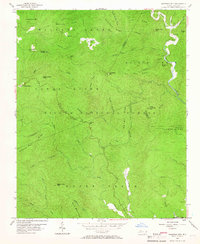
1956 Map of Chestnut Mtn.
USGS Topo · Published 1966About this map
Pisgah National Forest dominates this mid-century landscape, where the confluence of three North Carolina counties—Avery, Burke, and Caldwell—meets among the high peaks and deep drainages of the Blue Ridge. The settlement of Mortimer and the nearby Estes Mill sit along Wilson Creek, illustrating the remote river-based operations of the era. The terrain is marked by significant physical landmarks like Jonas Ridge, Ripshin Ridge, and Licklog Gap, which dictated the path of early travel routes and modern engineering like the Blue Ridge Parkway. The interior is defined by a dense network of watercourses including North Harper Creek and Upper Creek, which flow through heavily timbered valleys. Small community markers, such as Parks Cem and the settlement of Kawana, provide key touchpoints for genealogists tracing families in these rugged borderlands between the mountain crests and the Johns River basin.
Find a feature on this map
54 named features on this map. Tap any name to fly to it.
Don’t see what you’re looking for? This feature index may not catch every label — zoom into the map to look around manually.
Map Details
Editions of this 1956 Chestnut Mtn. Map
4 editions found
Other maps of this area

1893 · Cranberry
USGS Topo · 1:125,000

1895 · Cranberry
USGS Topo · 1:125,000

1899 · Cranberry
USGS Topo · 1:125,000

1902 · Cranberry
USGS Topo · 1:125,000

1905 · Morganton
USGS Topo · 1:125,000

1934 · Linville Falls
USGS Topo · 1:24,000

1934 · Newland
USGS Topo · 1:24,000

1936 · Blowing Rock
USGS Topo · 1:48,000

1942 · Blowing Rock
USGS Topo · 1:62,500

1944 · Linville
USGS Topo · 1:62,500