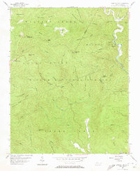
1956 Map of Chestnut Mtn.
USGS Topo · Published 1973About this map
Pisgah National Forest encompasses nearly this entire 1956 landscape, where the borders of Avery, Burke, and Caldwell counties converge among a complex system of ridges and drainages. The small settlement of Mortimer sits along Wilson Creek, a primary waterway that carved much of the eastern terrain alongside Thorps Creek and Harper Creek. Further west, the Blue Ridge Parkway skirts the edge of Jonas Ridge, providing a modern transport contrast to the older network of forest ridges like Lettered Rock Ridge and Old Way Ridge.
Find a feature on this map
54 named features on this map. Tap any name to fly to it.
Don’t see what you’re looking for? This feature index may not catch every label — zoom into the map to look around manually.
Map Details
Editions of this 1956 Chestnut Mtn. Map
4 editions found
Other maps of this area

1893 · Cranberry
USGS Topo · 1:125,000

1895 · Cranberry
USGS Topo · 1:125,000

1899 · Cranberry
USGS Topo · 1:125,000

1902 · Cranberry
USGS Topo · 1:125,000

1905 · Morganton
USGS Topo · 1:125,000

1934 · Linville Falls
USGS Topo · 1:24,000

1934 · Newland
USGS Topo · 1:24,000

1936 · Blowing Rock
USGS Topo · 1:48,000

1942 · Blowing Rock
USGS Topo · 1:62,500

1944 · Linville
USGS Topo · 1:62,500