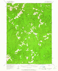
1954 Map of Chetco Peak
USGS Topo · Published 1961About this map
Siskiyou National Forest dominates this mid-century landscape, a territory defined by the headwaters of the Chetco River and the North Fork Smith River. Remote outposts and seasonal dwellings such as Bailey Cabin, Emily Cabin, and McKee Cabin are scattered throughout the drainage basins, reflecting an era of backcountry management and subsistence. The topography is anchored by high summits including Chetco Peak and Vulcan Peak, which provided essential vantage points for fire suppression, as evidenced by the Canyon Pk Lookout and the Cleopatra Lookout.
Find a feature on this map
74 named features on this map. Tap any name to fly to it.
Don’t see what you’re looking for? This feature index may not catch every label — zoom into the map to look around manually.
Map Details
Editions of this 1954 Chetco Peak Map
4 editions found

Other maps of this area

1917 · Kerby
USGS Topo · 1:125,000

1918 · Kerby
USGS Topo · 1:125,000

1922 · Preston Peak
USGS Topo · 1:125,000

1929 · Crescent City
USGS Topo · 1:125,000

1945 · Kerby
USGS Topo · 1:125,000

1945 · Gasquet
USGS Topo · 1:62,500

1945 · Point St. George
USGS Topo · 1:62,500

1948 · Weed
USGS Topo · 1:250,000

1949 · Eureka
USGS Topo · 1:250,000

1950 · Weed
USGS Topo · 1:250,000