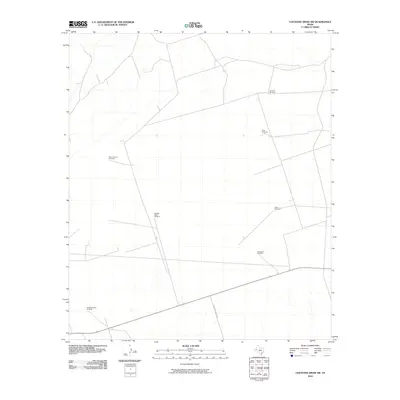
2010 Map of Cheyenne Draw SW
USGS Topo · Published 2010About this map
Windmills define the arid landscape of this southwestern corner of the Cheyenne Draw region, marking essential water sources for cattle and ranching operations. In a territory where surface water is scarce, family and ranch-named landmarks like the Lineberry Windmill and Pemm Windmill serve as primary navigational points across the open range. The layout of the land is further delineated by a network of ranching roads, including Anderson Ranch Rd, which connects these remote outposts. The concentration of features such as the West Lehman Windmill and the Westbrookfield Windmill illustrates the infrastructure required to sustain the ranching economy in this part of Loving County during the early 21st century. This survey documents the specific locations of vital water infrastructure and local access routes that have historically supported the area's agricultural life.
Find a feature on this map
8 named features on this map. Tap any name to fly to it.
Don’t see what you’re looking for? This feature index may not catch every label — zoom into the map to look around manually.
Map Details
Editions of this 2010 Cheyenne Draw SW Map
This is the sole edition of this map. No revisions or reprints were ever made.
Other maps of this area

1954 · Pecos
USGS Topo · 1:250,000

1957 · Pecos
USGS Topo · 1:250,000

1961 · Mentone
USGS Topo · 1:24,000

1967 · Soda Lake NW
USGS Topo · 1:24,000

1968 · Soda Lake NE
USGS Topo · 1:24,000

1969 · Cheyenne Draw SW
USGS Topo · 1:24,000

1969 · Rudd Draw NE
USGS Topo · 1:24,000
1969 · Rudd Draw
USGS Topo · 1:24,000

1970 · Brunson Ranch
USGS Topo · 1:24,000

1970 · Cheyenne Draw
USGS Topo · 1:24,000