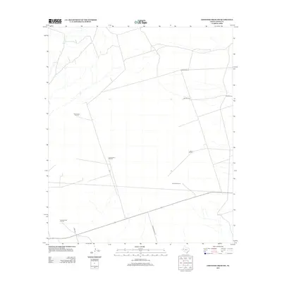
2012 Map of Cheyenne Draw SW
USGS Topo · Published 2012About this map
Lineberry Windmill and other scattered water infrastructure define the landscape of this arid Loving County region in the early twenty-first century. The map illustrates a ranching-driven economy where named water sources are the primary landmarks across the terrain. These range from the centrally located Shallow Water Windmill to the peripheral West Lehman Windmill and West Brookfield Windmill. Transportation is limited to a sparse network of local roads such as Anderson Ranch Rd and Creek 400, which provide access between these remote stations. This survey is a record of modern range management, highlighting how family and ranch names like Pemm Windmill and Brookfield Windmill serve as essential geographic markers in the Texas Permian Basin.
Find a feature on this map
10 named features on this map. Tap any name to fly to it.
Don’t see what you’re looking for? This feature index may not catch every label — zoom into the map to look around manually.
Map Details
Editions of this 2012 Cheyenne Draw SW Map
This is the sole edition of this map. No revisions or reprints were ever made.
Other maps of this area

1954 · Pecos
USGS Topo · 1:250,000

1957 · Pecos
USGS Topo · 1:250,000

1961 · Mentone
USGS Topo · 1:24,000

1967 · Soda Lake NW
USGS Topo · 1:24,000

1968 · Soda Lake NE
USGS Topo · 1:24,000

1969 · Cheyenne Draw SW
USGS Topo · 1:24,000

1969 · Rudd Draw NE
USGS Topo · 1:24,000
1969 · Rudd Draw
USGS Topo · 1:24,000

1970 · Brunson Ranch
USGS Topo · 1:24,000

1970 · Cheyenne Draw
USGS Topo · 1:24,000