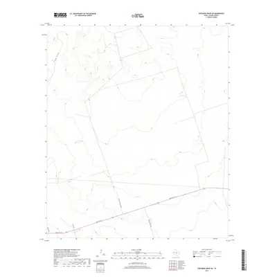
2019 Map of Cheyenne Draw SW
USGS Topo · Published 2019About this map
Rudd Draw winds through this arid corner of Loving County, defining a landscape marked by ranching infrastructure and desert navigation. The drainage patterns across this terrain emphasize the isolation and scale of West Texas, where local travel relies on routes like Ranch Rd 1211. This 2019 survey documents the modern ranching footprint, capturing specifically named local landmarks such as Purple Cattleguard Rd and Anderson Ranch Rd. These roads provide the primary structural framework for the area, connecting scattered operations across the wide, open reaches of the Permian Basin region. Historical researchers and land use students can trace the intersection of named county routes like Co Rd 400 and Boulder Rd as they segment the vast landscape near the Texas-New Mexico border.
Find a feature on this map
6 named features on this map. Tap any name to fly to it.
Don’t see what you’re looking for? This feature index may not catch every label — zoom into the map to look around manually.
Map Details
Editions of this 2019 Cheyenne Draw SW Map
This is the sole edition of this map. No revisions or reprints were ever made.
Other maps of this area

1954 · Pecos
USGS Topo · 1:250,000

1957 · Pecos
USGS Topo · 1:250,000

1961 · Mentone
USGS Topo · 1:24,000

1967 · Soda Lake NW
USGS Topo · 1:24,000

1968 · Soda Lake NE
USGS Topo · 1:24,000

1969 · Cheyenne Draw SW
USGS Topo · 1:24,000

1969 · Rudd Draw NE
USGS Topo · 1:24,000
1969 · Rudd Draw
USGS Topo · 1:24,000

1970 · Brunson Ranch
USGS Topo · 1:24,000

1970 · Cheyenne Draw
USGS Topo · 1:24,000