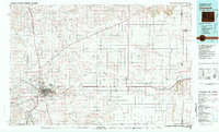
1981 Map of Cheyenne
USGS Topo · Published 1981About this map
Cheyenne serves as the focal point of this 1981 survey, marking a significant crossroads where the Union Pacific railroad and major interstate corridors like 80 and 25 converge. The landscape is defined by the strategic presence of Francis E Warren Air Force Base and the Municipal Airport, illustrating the area's importance to national defense and transportation during the late twentieth century. Moving east toward the Nebraska border, the terrain transitions into a grid of agricultural and ranching lands dotted with smaller settlements such as Burns, Hillsdale, and Egbert.
Find a feature on this map
53 named features on this map. Tap any name to fly to it.
Don’t see what you’re looking for? This feature index may not catch every label — zoom into the map to look around manually.
Map Details
Editions of this 1981 Cheyenne Map
2 editions found
Other maps of this area

1898 · Scotts Bluff
USGS Topo · 1:125,000

1899 · Goshen Hole
USGS Topo · 1:125,000

1905 · Sherman
USGS Topo · 1:125,000

1907 · Livermore
USGS Topo · 1:125,000

1908 · Eaton
USGS Topo · 1:125,000

1909 · Livermore
USGS Topo · 1:125,000

1910 · Eaton
USGS Topo · 1:125,000

1911 · Cheyenne
USGS Topo · 1:125,000

1914 · Cheyenne
USGS Topo · 1:125,000

1950 · Cheyenne
USGS Topo · 1:62,500