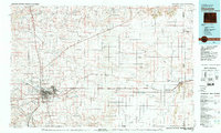
1981 Map of Cheyenne
USGS Topo · Published 1981About this map
Cheyenne stands as the primary hub of this 1981 survey, where the heavy industry of the Union Pacific and Colorado and Southern railroads meets the sprawling military installation at Francis E Warren Air Force Base. The map documents a transition from the dense urban grid and surrounding communities like Orchard Valley to the expansive high plains of Laramie County. To the east, the landscape is defined by the agricultural and transit corridor following Lodgepole Creek, punctuated by smaller prairie settlements including Hillsdale, Burns, and Pine Bluffs.
Find a feature on this map
69 named features on this map. Tap any name to fly to it.
Don’t see what you’re looking for? This feature index may not catch every label — zoom into the map to look around manually.
Map Details
Editions of this 1981 Cheyenne Map
2 editions found
Other maps of this area

1898 · Scotts Bluff
USGS Topo · 1:125,000

1899 · Goshen Hole
USGS Topo · 1:125,000

1905 · Sherman
USGS Topo · 1:125,000

1907 · Livermore
USGS Topo · 1:125,000

1908 · Eaton
USGS Topo · 1:125,000

1909 · Livermore
USGS Topo · 1:125,000

1910 · Eaton
USGS Topo · 1:125,000

1911 · Cheyenne
USGS Topo · 1:125,000

1914 · Cheyenne
USGS Topo · 1:125,000

1950 · Cheyenne
USGS Topo · 1:62,500