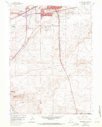
1961 Map of Cheyenne South
USGS Topo · Published 1970About this map
The sprawling rail and radio infrastructure of the southern edge of Cheyenne dominates this survey, where the Union Pacific and Colorado and Southern lines converge. The landscape is a mix of urban expansion into Orchard Valley and the open range of the Terry Anticline to the south. Distinctive mid-century features like the Intermountain Speedway, a Drive-in Theater, and a cluster of broadcast sites including Radio Tower (KVWO) and Radio Tower (KCHY) illustrate the city's growth along the major transport corridors. Further south, the map transitions into cattle country and small camps near the state line, such as Athol and State Line Camp. The inclusion of specific rural institutions like Rossman Sch and Goeins Sch provides a precise record of the educational landscape before widespread consolidation changed the character of Laramie County.
Find a feature on this map
35 named features on this map. Tap any name to fly to it.
Don’t see what you’re looking for? This feature index may not catch every label — zoom into the map to look around manually.
Map Details
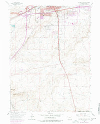
Editions of this 1961 Cheyenne South Map
3 editions found

Other maps of this area

1908 · Eaton
USGS Topo · 1:125,000

1910 · Eaton
USGS Topo · 1:125,000

1911 · Cheyenne
USGS Topo · 1:125,000

1914 · Cheyenne
USGS Topo · 1:125,000

1950 · Cheyenne
USGS Topo · 1:62,500

1954 · Cheyenne
USGS Topo · 1:250,000

1954 · Greeley
USGS Topo · 1:250,000

1957 · Greeley
USGS Topo · 1:250,000

1958 · Cheyenne
USGS Topo · 1:250,000

1958 · Greeley
USGS Topo · 1:250,000