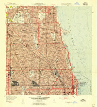
1953 Map of Chicago Loop
USGS Topo · Published 1956About this map
Lake Michigan dominates the eastern edge of this mid-century urban landscape, where the city’s dense street grid meets the carefully planned open spaces of Grant Park and Lincoln Park. This survey documents a critical period of infrastructure development, featuring the Congress Street Expressway cutting through the urban core and the established routes of the Chicago and North Western railroad. The map provides a detailed view of the city's complex social and institutional fabric, marking dozens of neighborhood parish schools like St Michael High Sch and St Benedict High Sch alongside major educational centers such as Northwestern University and De Paul University. Large-scale green spaces, including the sprawling Rosehill Cemetery and Graceland Cemetery, stand as significant landmarks within the northern residential districts. The industrial and maritime heart of the city is evident along the Chicago River and its Turning Basin, illustrating the intersection of waterborne commerce and dense metropolitan growth.
Find a feature on this map
57 named features on this map. Tap any name to fly to it.
Don’t see what you’re looking for? This feature index may not catch every label — zoom into the map to look around manually.
Map Details
Editions of this 1953 Chicago Loop Map
This is the sole edition of this map. No revisions or reprints were ever made.
Other maps of this area

1889 · Chicago
USGS Topo · 1:62,500

1891 · Chicago
USGS Topo · 1:62,500

1891 · Riverside
USGS Topo · 1:62,500

1893 · Riverside
USGS Topo · 1:62,500

1899 · Evanston
USGS Topo · 1:62,500

1900 · Chicago
USGS Topo · 1:62,500

1900 · Riverside
USGS Topo · 1:62,500

1900 · Highwood
USGS Topo · 1:62,500

1901 · Riverside
USGS Topo · 1:62,500

1901 · Chicago
USGS Topo · 1:62,500
Featured Places
- Chicago, IL
- Lincolnwood, IL
- Lake View Township, Chicago
- West Chicago Township, Chicago
- Jefferson Township, Chicago