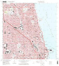
1997 Map of Chicago Loop
USGS Topo · Published 1999About this map
Lake Michigan dominates the eastern edge of this dense urban landscape, meeting a shoreline defined by the sprawling greenery of Lincoln Park and the engineering of Navy Pier. This 1990s survey shows the late-century infrastructure of Chicago, where the North Branch Chicago River and South Branch Chicago River bifurcate the city's grid. The map provides a detailed view of the city's massive necropolises, including Rosehill Cemetery, Graceland Cemetery, and the Bohemian Cemetery, reflecting the historical growth and diverse cultural heritage of the area.
Find a feature on this map
53 named features on this map. Tap any name to fly to it.
Don’t see what you’re looking for? This feature index may not catch every label — zoom into the map to look around manually.
Map Details
Editions of this 1997 Chicago Loop Map
This is the sole edition of this map. No revisions or reprints were ever made.
Other maps of this area

1889 · Chicago
USGS Topo · 1:62,500

1891 · Chicago
USGS Topo · 1:62,500

1891 · Riverside
USGS Topo · 1:62,500

1893 · Riverside
USGS Topo · 1:62,500

1899 · Evanston
USGS Topo · 1:62,500

1900 · Chicago
USGS Topo · 1:62,500

1900 · Riverside
USGS Topo · 1:62,500

1900 · Highwood
USGS Topo · 1:62,500

1901 · Riverside
USGS Topo · 1:62,500

1901 · Chicago
USGS Topo · 1:62,500
Featured Places
- Chicago, IL
- Lincolnwood, IL
- Lake View Township, Chicago
- West Chicago Township, Chicago
- Jefferson Township, Chicago