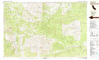
1981 Map of Chickabally Mtn
USGS Topo · Published 1981About this map
Chickabally Mtn dominates the high ground in this 1981 survey of the borderlands between Shasta and Tehama counties. The landscape is defined by the complex drainage network of the Middle Fork Cottonwood Creek and its many tributary gulches, including China Gulch and Dirty Gulch. Human presence is sparse, concentrated primarily at the small settlement of Rosewood near the eastern margin, which features a local Cem.
Find a feature on this map
46 named features on this map. Tap any name to fly to it.
Don’t see what you’re looking for? This feature index may not catch every label — zoom into the map to look around manually.
Map Details
Editions of this 1981 Chickabally Mtn Map
2 editions found
Other maps of this area

1890 · Red Bluff
USGS Topo · 1:250,000

1894 · Red Bluff
USGS Topo · 1:250,000

1932 · Olinda
USGS Topo · 1:31,680

1935 · Olinda
USGS Topo · 1:31,680

1947 · Anderson
USGS Topo · 1:62,500

1948 · Anderson
USGS Topo · 1:62,500

1949 · Colyear Springs
USGS Topo · 1:62,500

1951 · Chanchelulla Peak
USGS Topo · 1:62,500

1952 · Blossom
USGS Topo · 1:24,000

1952 · Ono
USGS Topo · 1:62,500