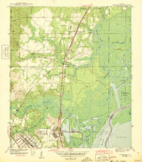
1943 Map of Chickasaw
USGS Topo · Published 1943About this map
Industrial activity and river transport dominate this coastal Alabama landscape, surveyed just as the region mobilized for wartime production. The Ship Yard at Chickasaw serves as a focal point near the confluence of Chickasaw Creek and the Mobile River, where a dense network of railroads—including the Southern Railway, G M & N RR, and the Terminal Ry—converges to move materials through the bay. To the north and west, residential settlements like Satsuma, Saraland, and Eight Mile appear alongside family-named landmarks such as Alvarez Bridge and Shelton Beach.
Find a feature on this map
45 named features on this map. Tap any name to fly to it.
Don’t see what you’re looking for? This feature index may not catch every label — zoom into the map to look around manually.
Map Details
Editions of this 1943 Chickasaw Map
3 editions found

Other maps of this area

1921 · Fairhope
USGS Topo · 1:62,500

1922 · Mobile
USGS Topo · 1:62,500

1940 · Mobile
USGS Topo · 1:31,680

1940 · Mobile
USGS Topo · 1:62,500

1941 · Chickasaw
USGS Topo · 1:31,680

1941 · Blakeley
USGS Topo · 1:31,680

1941 · Bay Minette
USGS Topo · 1:62,500

1941 · Creola
USGS Topo · 1:62,500

1941 · Fairhope
USGS Topo · 1:62,500

1942 · Hurricane
USGS Topo · 1:31,680