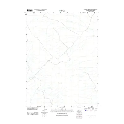
2012 Map of Chicken Creek East
USGS Topo · Published 2012About this map
Kinney Rim dominates this high-desert landscape in Sweetwater County, where seasonal drainage networks define the topography. The intermittent flows of Chicken Cr and Alkali Cr traverse the high plains, converging near the isolated landmark of Davis Cabin. This region is characterized by vast open range and remote access points, primarily serviced by unpaved routes like Bitter Creek Rd and BLM Road 4407. A critical water source in this arid environment is identified at Carson Spring, located in the north-central portion of the quadrangle. The map illustrates a modern state of land management and resource location, highlighting the sparse but vital infrastructure used for ranching and public land navigation in the early twenty-first century.
Find a feature on this map
7 named features on this map. Tap any name to fly to it.
Don’t see what you’re looking for? This feature index may not catch every label — zoom into the map to look around manually.
Map Details
Editions of this 2012 Chicken Creek East Map
This is the sole edition of this map. No revisions or reprints were ever made.
Other maps of this area

1954 · Rock Springs
USGS Topo · 1:250,000

1958 · Rock Springs
USGS Topo · 1:250,000

1962 · Rock Springs
USGS Topo · 1:250,000

1968 · Chicken Creek East
USGS Topo · 1:24,000
1968 · Chicken Creek SW
USGS Topo · 1:24,000

1968 · Pine Butte
USGS Topo · 1:24,000

1968 · Sand Butte Rim SE
USGS Topo · 1:24,000
1968 · Chicken Creek SE
USGS Topo · 1:24,000
1968 · Chicken Creek West
USGS Topo · 1:24,000

1970 · Cow Creek Reservoir
USGS Topo · 1:24,000