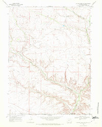
1968 Map of Chicken Creek SW
USGS Topo · Published 1972About this map
The high desert landscape straddling the Wyoming and Colorado state line is defined by the sharp transition between the northern plateaus and the deep drainage basins to the south. Vermillion Creek and its tributary, Alkali Creek, carve intricate canyon systems through the terrain, joined by the distinctive Horseshoe Wash in the southern portion of the quadrangle. This mid-century survey reveals a territory primarily utilized for resource extraction, evidenced by the numerous Gas Wells and scattered Drill Holes dotting the ridges. A major Pipeline cuts across the center of the sheet, illustrating the industrial infrastructure developed to transport energy resources from this remote borderland at the edge of Sweetwater and Moffat Counties.
Find a feature on this map
10 named features on this map. Tap any name to fly to it.
Don’t see what you’re looking for? This feature index may not catch every label — zoom into the map to look around manually.
Map Details
Editions of this 1968 Chicken Creek SW Map
This is the sole edition of this map. No revisions or reprints were ever made.
Other maps of this area

1954 · Vernal
USGS Topo · 1:250,000

1954 · Rock Springs
USGS Topo · 1:250,000

1958 · Vernal
USGS Topo · 1:250,000

1958 · Rock Springs
USGS Topo · 1:250,000

1960 · Vernal
USGS Topo · 1:250,000

1962 · Rock Springs
USGS Topo · 1:250,000

1963 · Erickson-Kent Ranch
USGS Topo · 1:24,000

1963 · Scrivner Butte
USGS Topo · 1:24,000

1966 · Sugarloaf Butte
USGS Topo · 1:24,000
1966 · Sparks
USGS Topo · 1:24,000