
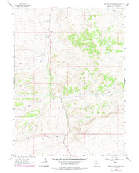
1963 Map of Erickson-Kent Ranch
USGS Topo · Published 1966About this map
Erickson-Kent Ranch serves as a primary human landmark in this high-desert landscape of south-central Wyoming, documented during a 1963 field check. The terrain is defined by the prominent Rifes Rim, which cuts across the southern portion of the quadrangle, creating a distinct geological break in the high plateau. Drainage patterns are vital to understanding the geography here, with East Salt Wells Creek winding northward through the center of the sheet. This seasonal water system is fed by numerous ephemeral channels, including Brooks Draw, Scheggs Draw, and West Draw. The map reflects an era of resource exploration and cattle ranching, where isolated outposts like the ranch and various Drill Holes represent the sparse but significant human footprint on the Sweetwater County range.
Find a feature on this map
8 named features on this map. Tap any name to fly to it.
Don’t see what you’re looking for? This feature index may not catch every label — zoom into the map to look around manually.
Map Details
Editions of this 1963 Erickson-Kent Ranch Map
2 editions found
Other maps of this area

1954 · Rock Springs
USGS Topo · 1:250,000

1958 · Rock Springs
USGS Topo · 1:250,000

1962 · Rock Springs
USGS Topo · 1:250,000

1963 · Four J Rim
USGS Topo · 1:24,000
1963 · Potter Mountain
USGS Topo · 1:24,000

1963 · Scrivner Butte
USGS Topo · 1:24,000
1968 · Chicken Creek SW
USGS Topo · 1:24,000

1968 · Mud Springs Ranch
USGS Topo · 1:24,000

1968 · Pine Butte
USGS Topo · 1:24,000
1968 · Burley Draw
USGS Topo · 1:24,000