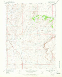
1968 Map of Burley Draw
USGS Topo · Published 1972About this map
Salt Wells Creek and its southern tributaries define the high-desert drainage patterns of this Sweetwater County landscape during the late 1960s. The terrain is characterized by a complex network of seasonal washes and draws, including Alkali Wash, Scheggs Draw, and Cedar Draw, which carve through the arid plateau. A prominent Rim feature in the southeast overlooks the winding course of the creek, illustrating the stark topographic relief of the region.
Find a feature on this map
11 named features on this map. Tap any name to fly to it.
Don’t see what you’re looking for? This feature index may not catch every label — zoom into the map to look around manually.
Map Details
Editions of this 1968 Burley Draw Map
This is the sole edition of this map. No revisions or reprints were ever made.
Other maps of this area

1954 · Rock Springs
USGS Topo · 1:250,000

1958 · Rock Springs
USGS Topo · 1:250,000

1962 · Rock Springs
USGS Topo · 1:250,000
1963 · Potter Mountain
USGS Topo · 1:24,000

1963 · Erickson-Kent Ranch
USGS Topo · 1:24,000

1968 · Cooper Ridge NE
USGS Topo · 1:24,000

1968 · Sand Butte Rim NW
USGS Topo · 1:24,000

1968 · Mud Springs Ranch
USGS Topo · 1:24,000

1968 · Pine Butte
USGS Topo · 1:24,000

1968 · Camel Rock
USGS Topo · 1:24,000