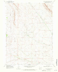
1968 Map of Chicken Creek West
USGS Topo · Published 1972About this map
Kinney Rim and Rifes Rim dominate this high desert landscape in Sweetwater County, forming a dramatic escarpment that overlooks the Chicken Springs Basin. This late-1960s survey documents a region defined by its drainage systems and emerging industrial footprint. Seasonal watercourses like Chicken Creek, Alkali Creek, and Scheggs Draw carve through the arid terrain, while numerous springs provide vital water points in an otherwise dry expanse. The map records the early stages of energy exploration in the area, indicated by several scattered drill holes and gas wells. A prominent Pipeline traverses the southern sections, marking the infrastructure required to transport resources from this remote part of Wyoming. Other topographical features such as East Draw and Granary Draw provide further detail on the intricate erosional patterns of the local geology.
Find a feature on this map
15 named features on this map. Tap any name to fly to it.
Don’t see what you’re looking for? This feature index may not catch every label — zoom into the map to look around manually.
Map Details
Editions of this 1968 Chicken Creek West Map
2 editions found
Other maps of this area

1954 · Rock Springs
USGS Topo · 1:250,000

1958 · Rock Springs
USGS Topo · 1:250,000

1962 · Rock Springs
USGS Topo · 1:250,000

1963 · Erickson-Kent Ranch
USGS Topo · 1:24,000

1963 · Scrivner Butte
USGS Topo · 1:24,000

1968 · Chicken Creek East
USGS Topo · 1:24,000
1968 · Chicken Creek SW
USGS Topo · 1:24,000

1968 · Pine Butte
USGS Topo · 1:24,000

1968 · Sand Butte Rim SE
USGS Topo · 1:24,000
1968 · Burley Draw
USGS Topo · 1:24,000