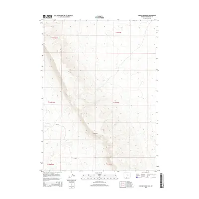
2015 Map of Chicken Creek East
USGS Topo · Published 2015About this map
Kinney Rim dominates this high-desert landscape in Sweetwater County, forming a massive natural escarpment that dictates the flow of ephemeral drainages across the plateau. The terrain is defined by the sharp vertical relief of the rim, where the headwaters of Chicken Cr and Alkali Cr emerge from the western slopes. These watercourses represent critical seasonal resources in an otherwise arid environment, supplemented by groundwater points like Carson Spring. Navigation through this isolated corridor relies on unpaved access routes such as Blm-4407, which connects the high ridges to the surrounding basins. The map illustrates a stark, open landscape where topography is the primary feature, reflecting the land use patterns typical of Wyoming's public lands under the Bureau of Land Management.
Find a feature on this map
11 named features on this map. Tap any name to fly to it.
Don’t see what you’re looking for? This feature index may not catch every label — zoom into the map to look around manually.
Map Details
Editions of this 2015 Chicken Creek East Map
This is the sole edition of this map. No revisions or reprints were ever made.
Other maps of this area

1954 · Rock Springs
USGS Topo · 1:250,000

1958 · Rock Springs
USGS Topo · 1:250,000

1962 · Rock Springs
USGS Topo · 1:250,000

1968 · Chicken Creek East
USGS Topo · 1:24,000
1968 · Chicken Creek SW
USGS Topo · 1:24,000

1968 · Pine Butte
USGS Topo · 1:24,000

1968 · Sand Butte Rim SE
USGS Topo · 1:24,000
1968 · Chicken Creek SE
USGS Topo · 1:24,000
1968 · Chicken Creek West
USGS Topo · 1:24,000

1970 · Cow Creek Reservoir
USGS Topo · 1:24,000