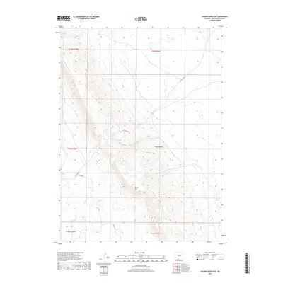
2017 Map of Chicken Creek East
USGS Topo · Published 2017About this map
Kinney Rim dominates the central topography of this Sweetwater County quadrant, creating a significant elevation change across the high desert landscape. The terrain is marked by seasonal drainages including Chicken Cr and Alkali Cr, which underscore the arid conditions of this portion of Wyoming. Remote access to the area is facilitated by Bitter Creek Rd and BLM Rd 4407, reflecting the importance of Bureau of Land Management infrastructure in maintaining connectivity across these open rangelands. A singular water source, Carson Spring, appears on the northeastern slopes, a vital landmark for both wildlife and regional land management. The grid of township and range lines, such as t14n r99w, provides the primary structure for navigating this largely undeveloped expanse.
Find a feature on this map
12 named features on this map. Tap any name to fly to it.
Don’t see what you’re looking for? This feature index may not catch every label — zoom into the map to look around manually.
Map Details
Editions of this 2017 Chicken Creek East Map
This is the sole edition of this map. No revisions or reprints were ever made.
Other maps of this area

1954 · Rock Springs
USGS Topo · 1:250,000

1958 · Rock Springs
USGS Topo · 1:250,000

1962 · Rock Springs
USGS Topo · 1:250,000

1968 · Chicken Creek East
USGS Topo · 1:24,000
1968 · Chicken Creek SW
USGS Topo · 1:24,000

1968 · Pine Butte
USGS Topo · 1:24,000

1968 · Sand Butte Rim SE
USGS Topo · 1:24,000
1968 · Chicken Creek SE
USGS Topo · 1:24,000
1968 · Chicken Creek West
USGS Topo · 1:24,000

1970 · Cow Creek Reservoir
USGS Topo · 1:24,000