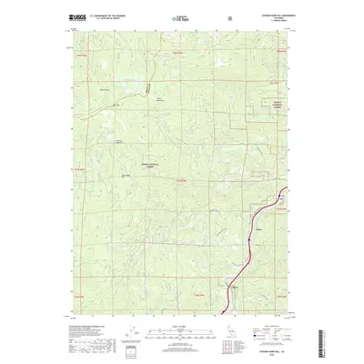
2018 Map of Chicken Hawk Hill
USGS Topo · Published 2018About this map
Shasta National Forest dominates this mountain landscape where the Trinity Co Shasta Co line runs through the high peaks of the Trinity Mountains. This 2018 survey documents a region defined by steep drainage networks and local mineral history, notably at Shiloh Mineral Springs along the eastern edge. The Sacramento River flows through the canyon floor near the settlement of Fisher, paralleled by the main transportation corridor through this difficult terrain. Higher elevations feature distinctive summits like Chicken Hawk Hill and Rattlesnake Hill, while smaller alpine waters such as Tamarack Lake and Grey Rock Lake sit tucked into glacial cirques and high basins. The map captures the complex system of forest service routes, including Shotgun Creek Rd and Highland Lakes Rd, which provide access to the remote timber and watershed lands of the interior.
Find a feature on this map
46 named features on this map. Tap any name to fly to it.
Don’t see what you’re looking for? This feature index may not catch every label — zoom into the map to look around manually.
Map Details
Editions of this 2018 Chicken Hawk Hill Map
This is the sole edition of this map. No revisions or reprints were ever made.
Other maps of this area

1886 · Shasta
USGS Topo · 1:250,000

1890 · Red Bluff
USGS Topo · 1:250,000

1894 · Red Bluff
USGS Topo · 1:250,000

1894 · Shasta
USGS Topo · 1:250,000

1901 · Redding
USGS Topo · 1:125,000

1913 · Weaverville
USGS Topo · 1:125,000

1923 · Sawyers Bar
USGS Topo · 1:125,000

1931 · Etna
USGS Topo · 1:96,000

1934 · Etna
USGS Topo · 1:125,000

1935 · Dunsmuir
USGS Topo · 1:125,000