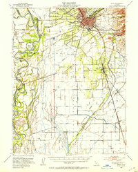
1949 Map of Chico
USGS Topo · Published 1953About this map
The agricultural and academic heart of Northern California is captured here at mid-century, centered on the growing community of Chico. The city is anchored by the campus of Chico State College and surrounded by a network of suburban settlements such as Barber, Chapmantown, and Stirling Junction. Industry of the era is evident through the presence of the Match Factory and a sprawling rail system dominated by the Southern Pacific and Sacramento Northern lines. To the west, the Sacramento River meanders through a landscape of river islands including Phelan Island and Golden State Island. The survey details an intricate water system of sloughs and channels, such as Lindo Channel and Edgar Slough, which supported the surrounding orchards and farms near Durham and Dayton.
Find a feature on this map
58 named features on this map. Tap any name to fly to it.
Don’t see what you’re looking for? This feature index may not catch every label — zoom into the map to look around manually.
Map Details
Editions of this 1949 Chico Map
3 editions found
Other maps of this area

1888 · Marysville
USGS Topo · 1:125,000

1891 · Chico
USGS Topo · 1:125,000

1891 · Marysville
USGS Topo · 1:125,000

1893 · Chico
USGS Topo · 1:125,000

1894 · Marysville
USGS Topo · 1:125,000

1895 · Marysville
USGS Topo · 1:125,000

1895 · Chico
USGS Topo · 1:125,000

1904 · Vina
USGS Topo · 1:62,500

1906 · Maxwell
USGS Topo · 1:62,500

1906 · Willows
USGS Topo · 1:62,500