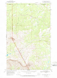
1968 Map of Chief Mountain
USGS Topo · Published 1987About this map
The Blackfeet Indian Reservation Boundary serves as a stark dividing line in this 1968 landscape, separating the high peaks of Glacier National Park from the reservation lands to the east. The prominent peak of Chief Mountain dominates the western topography, while the Chief Mountain International Highway winds through the north, crossing the Canada United States border. This survey captures a rugged frontier environment where infrastructure is limited to Patrol Cabins and a few isolated Drill Holes, emphasizing the area's role as a protected wilderness and trans-border corridor.
Find a feature on this map
23 named features on this map. Tap any name to fly to it.
Don’t see what you’re looking for? This feature index may not catch every label — zoom into the map to look around manually.
Map Details
Editions of this 1968 Chief Mountain Map
3 editions found
Other maps of this area

1901 · Browning
USGS Topo · 1:125,000

1903 · Browning
USGS Topo · 1:125,000

1904 · Chief Mountain
USGS Topo · 1:125,000

1938 · Chief Mountain
USGS Topo · 1:125,000

1960 · Cut Bank
USGS Topo · 1:250,000

1963 · Cut Bank
USGS Topo · 1:250,000

1964 · Cut Bank
USGS Topo · 1:250,000

1968 · Gable Mountain
USGS Topo · 1:24,000

1968 · Babb
USGS Topo · 1:24,000
1968 · Chief Mountain
USGS Topo · 1:24,000