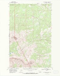
1968 Map of Chief Mountain
USGS Topo · Published 1987About this map
Chief Mountain stands as a massive focal point where the eastern boundary of Glacier National Park meets the Blackfeet Indian Reservation Boundary and the international border. This 1968 survey details a transition from the high peaks of Yellow Mountain and Sherburne Peak to the drainages of Lee Creek and Kennedy Creek. The map records essential backcountry infrastructure for the era, including remote Patrol Cabins and the Gable Pass Trail. The presence of the Chief Mountain International Highway provides the primary passage through this mountainous corridor, while features like the Borrow Pit and various Drill Hole markers indicate human activity and resource exploration within the Montana-Alberta borderlands.
Find a feature on this map
23 named features on this map. Tap any name to fly to it.
Don’t see what you’re looking for? This feature index may not catch every label — zoom into the map to look around manually.
Map Details
Editions of this 1968 Chief Mountain Map
3 editions found
Other maps of this area

1901 · Browning
USGS Topo · 1:125,000

1903 · Browning
USGS Topo · 1:125,000

1904 · Chief Mountain
USGS Topo · 1:125,000

1938 · Chief Mountain
USGS Topo · 1:125,000

1960 · Cut Bank
USGS Topo · 1:250,000

1963 · Cut Bank
USGS Topo · 1:250,000

1964 · Cut Bank
USGS Topo · 1:250,000

1968 · Gable Mountain
USGS Topo · 1:24,000

1968 · Babb
USGS Topo · 1:24,000
1968 · Chief Mountain
USGS Topo · 1:24,000