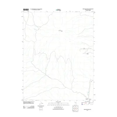
2012 Map of Chief Mountain
USGS Topo · Published 2012About this map
Chief Mountain and the surrounding Chief Range dominate this 2012 survey of the high desert terrain north of the railroad hub of Caliente. The landscape is defined by deep drainages and canyons, including the prominent Chief Canyon and Cobalt Canyon, which cut through the uplifted rock. Water is a critical and sparse resource in this environment, marked by the presence of George Roger Spring and Klondike Spring at higher elevations, while Meadow Valley Wash defines the lower drainage patterns to the southeast. Transport in this corner of Lincoln County is largely restricted to rugged routes like Antelope Canyon Rd, which provides access to the eponymous Antelope Canyon. This modern topographic study preserves the naming of specific landmarks and springs essential to navigation and land management in the Nevada backcountry.
Find a feature on this map
10 named features on this map. Tap any name to fly to it.
Don’t see what you’re looking for? This feature index may not catch every label — zoom into the map to look around manually.
Map Details
Editions of this 2012 Chief Mountain Map
This is the sole edition of this map. No revisions or reprints were ever made.
Other maps of this area

1885 · Pioche
USGS Topo · 1:250,000

1886 · Pioche
USGS Topo · 1:250,000

1916 · Highland
USGS Topo · 1:62,500

1918 · Highland
USGS Topo · 1:62,500

1921 · NW 1/4 Panaca
USGS Topo · 1:48,000

1954 · Caliente
USGS Topo · 1:250,000

1959 · Caliente
USGS Topo · 1:250,000
1970 · The Bluffs
USGS Topo · 1:24,000
1970 · Bennett Pass
USGS Topo · 1:24,000
1970 · Caliente NW
USGS Topo · 1:24,000