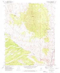
1970 Map of Chief Mountain
USGS Topo · Published 1974About this map
Chief Range dominates this 1970 study of Lincoln County terrain, anchored by the prominent summit of Chief Mountain. The landscape is defined by the steep transition from high peaks to the branching drainage systems of Antelope Canyon and Chief Canyon. At the southern edge of the sheet, the town of Caliente sits at the junction of the Union Pacific railroad and the Meadow Valley Wash, illustrating the vital intersection of rail transport and water resources in the high desert. Scattered across the hillsides are markers of early mineral exploration and ranching infrastructure, including a prospect, the Cobalt site, and the isolated George Roger Well. A network of rugged tracks, labeled simply as Jeep Trail, provides the only access into the high country and the Klondike Spring area, revealing how much of this landscape remained remote and accessible only by four-wheel drive during the 1970s.
Find a feature on this map
28 named features on this map. Tap any name to fly to it.
Don’t see what you’re looking for? This feature index may not catch every label — zoom into the map to look around manually.
Map Details
Editions of this 1970 Chief Mountain Map
This is the sole edition of this map. No revisions or reprints were ever made.
Other maps of this area

1885 · Pioche
USGS Topo · 1:250,000

1886 · Pioche
USGS Topo · 1:250,000

1916 · Highland
USGS Topo · 1:62,500

1918 · Highland
USGS Topo · 1:62,500

1921 · NW 1/4 Panaca
USGS Topo · 1:48,000

1954 · Caliente
USGS Topo · 1:250,000

1959 · Caliente
USGS Topo · 1:250,000
1970 · The Bluffs
USGS Topo · 1:24,000
1970 · Bennett Pass
USGS Topo · 1:24,000
1970 · Caliente NW
USGS Topo · 1:24,000