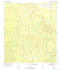
1954 Map of Chiefland SW
USGS Topo · Published 1971About this map
Gulf Hammock dominates this coastal landscape in the mid-1950s, revealing a dense network of marshes and lowlands characteristic of the Florida Gulf coast. The topography is exceptionally subtle, with much of the land sitting just above sea level. In this era, the settlement of Sumner appears as a small cluster of structures along the road, serving as a focal point for the surrounding wetlands. The survey reveals a landscape defined by its hydrology, where drainage patterns and swampy terrain dictate the placement of human activity. The boundary between T. 13 S. and T. 14 S. runs through the central portion of the sheet, providing a primary reference for property and genealogical research in this part of Levy County.
Find a feature on this map
3 named features on this map. Tap any name to fly to it.
Don’t see what you’re looking for? This feature index may not catch every label — zoom into the map to look around manually.
Map Details
Editions of this 1954 Chiefland SW Map
3 editions found
Other maps of this area

1954 · Chiefland
USGS Topo · 1:24,000

1954 · Otter Creek
USGS Topo · 1:24,000

1954 · Manatee Springs
USGS Topo · 1:24,000

1954 · Chiefland SW
USGS Topo · 1:24,000

1954 · Vista
USGS Topo · 1:24,000

1954 · East Pass
USGS Topo · 1:24,000

1954 · Gainesville
USGS Topo · 1:250,000

1955 · Cedar Key
USGS Topo · 1:24,000

1955 · Waccasassa Bay
USGS Topo · 1:24,000

1955 · Sumner
USGS Topo · 1:24,000