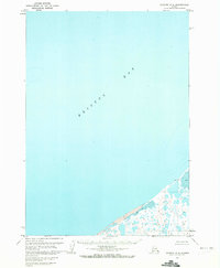
1963 Map of Chignik D-4
USGS Topo · Published 1972About this map
Bristol Bay dominates this coastal survey, where the vast marine environment of the Aleutian region meets a shoreline defined by shifting waters and unnamed coastal lakes. Based on 1950s aerial photography and 1960s field annotations, the map reveals a remote landscape where the boundary between land and sea is punctuated by features like Tidal flats and Mud deposits. A single Cabin appears near the northeast coast, serving as one of the few indicators of human presence in this maritime wilderness. Small inland water bodies like Lilac and Flat are clustered near the shore, reflecting the intricate hydrology of the Alaska Peninsula. This 1972 publication incorporates hydrographic data from USC&GS Chart 8834, detailing the depth curves and soundings vital to understanding the underwater topography of this subarctic bay.
Find a feature on this map
6 named features on this map. Tap any name to fly to it.
Don’t see what you’re looking for? This feature index may not catch every label — zoom into the map to look around manually.
Map Details
Editions of this 1963 Chignik D-4 Map
2 editions found
Other maps of this area

1951 · Bristol Bay
USGS Topo · 1:250,000

1963 · Chignik C-3
USGS Topo · 1:63,360

1963 · Chignik C-4
USGS Topo · 1:63,360

1963 · Bristol Bay
USGS Topo · 1:250,000
1963 · Chignik D-4
USGS Topo · 1:63,360

1963 · Chignik D-3
USGS Topo · 1:63,360

1963 · Chignik C-5
USGS Topo · 1:63,360

1963 · Chignik
USGS Topo · 1:250,000
1967 · Bristol Bay
USGS Topo · 1:250,000
2020 · Chignik D-3 SW
USGS Topo · 1:25,000