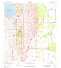
1953 Map of Childs
USGS Topo · Published 1971About this map
The Archbold Biological Station dominates this 1953 landscape in Highlands County, showcasing a critical intersection of conservation and infrastructure. The Atlantic Coast Line railroad runs north-south, linking the small settlements of Childs Station, Childs, and Hicoria. This rail corridor parallels a string of freshwater bodies including Lake Placid, Grassy Lake, and Lake Annie. To the east, the terrain transitions into a complex network of wetlands and seasonal drainages such as Hickory Branch and the expansive Bay Swamp. The map captures the region before significant modern development, emphasizing the relationship between the elevated sandy ridges and the surrounding low-lying bayheads and cypress strands. The presence of Bairs Den and Archbold suggests early 20th-century outposts in a territory characterized by its distinct Floridian hydrology and scrub habitats.
Find a feature on this map
19 named features on this map. Tap any name to fly to it.
Don’t see what you’re looking for? This feature index may not catch every label — zoom into the map to look around manually.
Map Details
Editions of this 1953 Childs Map
3 editions found
Other maps of this area

1952 · Lake Placid
USGS Topo · 1:24,000

1953 · Brighton NW
USGS Topo · 1:24,000

1953 · Lake June In Winter
USGS Topo · 1:24,000

1953 · Brighton SW
USGS Topo · 1:24,000

1953 · Venus NW
USGS Topo · 1:24,000

1953 · Basinger SW
USGS Topo · 1:24,000

1953 · Childs
USGS Topo · 1:24,000

1956 · Fort Pierce
USGS Topo · 1:250,000

1957 · Venus
USGS Topo · 1:24,000

1957 · Venus SW
USGS Topo · 1:24,000