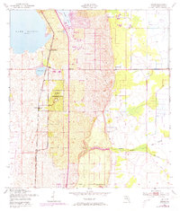
1953 Map of Childs
USGS Topo · Published 1973About this map
The Archbold Biological Station anchors this Highlands County landscape, preserving a significant portion of the Florida scrub ecosystem. This mid-century environment is defined by the Seaboard Coast Line railroad, which runs parallel to the eastern shore of Lake Placid. Small settlements and transit points like Childs, Bairs Den, and Hicoria follow this rail corridor, illustrating how transportation influenced early interior development. The topography transitions from the open waters of Lake Annie and Buck Lake in the west to the intricate drainages of Hickory Branch and Bay Swamp in the east. Notable for its ecological and local history, the map includes the ridge terrain of Parker Island and the specifically designated Childs Station, offering a clear view of the region's land use before late-century suburban expansion.
Find a feature on this map
22 named features on this map. Tap any name to fly to it.
Don’t see what you’re looking for? This feature index may not catch every label — zoom into the map to look around manually.
Map Details
Editions of this 1953 Childs Map
3 editions found
Other maps of this area

1952 · Lake Placid
USGS Topo · 1:24,000

1953 · Brighton NW
USGS Topo · 1:24,000

1953 · Lake June In Winter
USGS Topo · 1:24,000

1953 · Brighton SW
USGS Topo · 1:24,000

1953 · Venus NW
USGS Topo · 1:24,000

1953 · Basinger SW
USGS Topo · 1:24,000

1953 · Childs
USGS Topo · 1:24,000

1956 · Fort Pierce
USGS Topo · 1:250,000

1957 · Venus
USGS Topo · 1:24,000

1957 · Venus SW
USGS Topo · 1:24,000