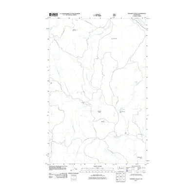
2011 Map of Chiliwist Valley
USGS Topo · Published 2011About this map
Olema sits at the heart of this Okanogan County landscape, where the agricultural life of the Chiliwist Valley meets the rising slopes of the Okanogan National Forest. This 2011 map reveals a rural network defined by family holdings and water management, notably at the Kercheval Ranch and Stout Ranch. The geography is centered on the drainage of Chiliwist Creek and its tributaries like Sullivan Creek, which are essential to the valley's character. High points such as Woody Mountain and Cook Mountain frame the northern reaches, while the Stout Reservoir Dam and Stout Reservoir represent significant water infrastructure for the local area. The map documents the persistent ranching identity of the region, anchored by the tiny settlement of Olema and a sparse but critical grid of mountain roads.
Find a feature on this map
26 named features on this map. Tap any name to fly to it.
Don’t see what you’re looking for? This feature index may not catch every label — zoom into the map to look around manually.
Map Details
Editions of this 2011 Chiliwist Valley Map
This is the sole edition of this map. No revisions or reprints were ever made.
Other maps of this area

1905 · Okanogan
USGS Topo · 1:125,000

1954 · Okanogan
USGS Topo · 1:250,000

1956 · Loup Loup
USGS Topo · 1:62,500

1957 · Okanogan
USGS Topo · 1:62,500

1957 · Bridgeport
USGS Topo · 1:62,500

1957 · Brewster
USGS Topo · 1:62,500

1958 · Okanogan
USGS Topo · 1:250,000
1980 · Monse
USGS Topo · 1:24,000
1980 · Ruby Hill
USGS Topo · 1:24,000
1981 · Malott
USGS Topo · 1:24,000