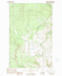
1989 Map of Chiliwist Valley
USGS Topo · Published 1989About this map
Chiliwist Valley serves as a central corridor for rural life in Okanogan County, where ranching and high-elevation terrain define the landscape. This 1980s-era survey documents the established homesteads of Kercheval Ranch and Stout Ranch, alongside the small settlement of Olema. The drainage of Chiliwist Creek and Sullivan Creek carved the valley floors between significant peaks such as Woody Mtn and Cook Mountain. To the west, the boundaries of the Okanogan National Forest border these private holdings, while the south is marked by the winding depths of Rowel Canyon. The presence of several corrals and established ranch names underscores the area's ongoing importance to the regional livestock economy during the late twentieth century.
Find a feature on this map
14 named features on this map. Tap any name to fly to it.
Don’t see what you’re looking for? This feature index may not catch every label — zoom into the map to look around manually.
Map Details
Editions of this 1989 Chiliwist Valley Map
This is the sole edition of this map. No revisions or reprints were ever made.
Other maps of this area

1905 · Okanogan
USGS Topo · 1:125,000

1954 · Okanogan
USGS Topo · 1:250,000

1956 · Loup Loup
USGS Topo · 1:62,500

1957 · Okanogan
USGS Topo · 1:62,500

1957 · Bridgeport
USGS Topo · 1:62,500

1957 · Brewster
USGS Topo · 1:62,500

1958 · Okanogan
USGS Topo · 1:250,000
1980 · Monse
USGS Topo · 1:24,000
1980 · Ruby Hill
USGS Topo · 1:24,000
1981 · Malott
USGS Topo · 1:24,000