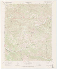
1967 Map of Chimney Canyon
USGS Topo · Published 1968About this map
The Cuyama River snakes through the high desert canyons of the Los Padres National Forest on this 1967 survey. This rugged landscape at the intersection of San Luis Obispo and Santa Barbara counties is defined by remote outposts such as Glines Ranch, Pernasse Ranch, and Rice Ranch. These isolated settlements are connected by a network of unimproved tracks and Jeep Trails that traverse steep terrain between Shell Peak and Stanley Mtn.
Find a feature on this map
33 named features on this map. Tap any name to fly to it.
Don’t see what you’re looking for? This feature index may not catch every label — zoom into the map to look around manually.
Map Details
Editions of this 1967 Chimney Canyon Map
2 editions found
Other maps of this area

1905 · Lompoc
USGS Topo · 1:125,000

1922 · Nipomo
USGS Topo · 1:62,500

1937 · Branch Mtn
USGS Topo · 1:48,000

1942 · Lompoc
USGS Topo · 1:125,000

1942 · Santa Maria
USGS Topo · 1:62,500

1942 · Branch Mountain
USGS Topo · 1:62,500

1942 · Tepusquet Peak
USGS Topo · 1:62,500

1943 · Tepusquet Peak
USGS Topo · 1:62,500

1943 · Lompoc
USGS Topo · 1:125,000
1947 · Los Coches Mtn
USGS Topo · 1:24,000