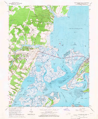
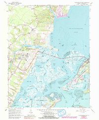
1965 Map of Chincoteague West
USGS Topo · Published 1966About this map
Chincoteague Island and its surrounding coastal marshes are captured here during a period of significant mid-century transition. The mainland is anchored by settlements such as Horntown and Wattsville, while the burgeoning University of Virginia Eastern Shore Branch suggests the era's educational expansion. To the south, the presence of the National Aeronautics and Space Administration (Wallops Island) reflects the region's role in the Cold War space race, contrasted by the enduring quiet of the Chincoteague National Wildlife Refuge. The map reveals a complex aquatic landscape of thoroughfares like the Chincoteague Channel and Queen Sound Channel, vital for the local maritime economy and the Coast Guard Station. From the small Tabernacle Ch to the various Sandpits, the sheet details the everyday infrastructure of Accomack County's eastern shore.
Find a feature on this map
94 named features on this map. Tap any name to fly to it.
Don’t see what you’re looking for? This feature index may not catch every label — zoom into the map to look around manually.
Map Details
Editions of this 1965 Chincoteague West Map
5 editions found
Other maps of this area

1901 · Snow Hill
USGS Topo · 1:62,500

1942 · Chincoteague East
USGS Topo · 1:24,000

1942 · Mappsville
USGS Topo · 1:24,000

1942 · Wallops Island
USGS Topo · 1:24,000

1943 · Boxiron
USGS Topo · 1:31,680

1943 · Mappsville
USGS Topo · 1:31,680

1943 · Chincoteague West
USGS Topo · 1:31,680
1943 · Girdletree
USGS Topo · 1:31,680
1943 · Hallwood
USGS Topo · 1:31,680
1943 · Pocomoke City
USGS Topo · 1:31,680