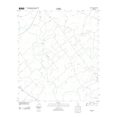
2013 Map of Choate
USGS Topo · Published 2013About this map
The San Antonio River meanders across this Karnes County landscape, defining the rural geography between the small settlements of Choate and Couch. This early 21st-century survey reveals a region deeply shaped by the petroleum industry, evidenced by the clustered operations at the Dunwolters Oil Field, Runge Oil Field, Janssen Oil Field, and Porter Oil Field. For local historians and genealogists, the Choate Cem provides a specific point of reference for the community's ancestral roots near the junction of several county roads.
Find a feature on this map
46 named features on this map. Tap any name to fly to it.
Don’t see what you’re looking for? This feature index may not catch every label — zoom into the map to look around manually.
Map Details
Editions of this 2013 Choate Map
This is the sole edition of this map. No revisions or reprints were ever made.
Other maps of this area

1936 · Pettus
USGS Topo · 1:62,500

1953 · Beeville
USGS Topo · 1:250,000

1956 · Beeville
USGS Topo · 1:250,000

1956 · Pettus
USGS Topo · 1:62,500

1956 · Karnes City
USGS Topo · 1:62,500

1960 · Beeville
USGS Topo · 1:250,000

1960 · Helena
USGS Topo · 1:24,000
1961 · Kenedy
USGS Topo · 1:24,000
1963 · Tulsita
USGS Topo · 1:24,000
1963 · Choate
USGS Topo · 1:24,000