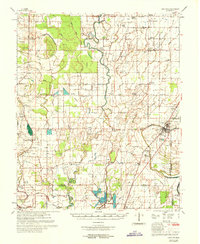
1969 Map of Choctaw
USGS Topo · Published 1969About this map
The Illinois Central Railroad corridor and U.S. Highway 61 define the eastern economic spine of this 1969 Mississippi Delta landscape, connecting the town of Shaw with smaller settlements like Porter and Laughlin. The terrain is marked by an intricate drainage system including the meandering Bogue Phalia, Snake Creek, and Stokes Bayou, alongside numerous flumes and canals required for large-scale agriculture. This map is particularly notable for its dense concentration of rural community centers, featuring a high number of churches such as the Mission Bautista Mexicana, Rock of Ages Ch, and Kindling Altar Ch.
Find a feature on this map
69 named features on this map. Tap any name to fly to it.
Don’t see what you’re looking for? This feature index may not catch every label — zoom into the map to look around manually.
Map Details
Editions of this 1969 Choctaw Map
This is the sole edition of this map. No revisions or reprints were ever made.
Other maps of this area

1931 · Drew
USGS Topo · 1:48,000

1933 · Lamont
USGS Topo · 1:62,500

1934 · Cleveland
USGS Topo · 1:62,500

1935 · Mound Bayou
USGS Topo · 1:62,500

1939 · Pace
USGS Topo · 1:62,500

1939 · Big Island
USGS Topo · 1:62,500

1939 · Refuge
USGS Topo · 1:62,500

1939 · Lamont
USGS Topo · 1:62,500

1939 · Tralake
USGS Topo · 1:62,500

1939 · Choctaw
USGS Topo · 1:62,500